
A traverse survey is a type of control survey that involves the establishment of a series of points that are linked together by lines to form a framework. The series of straight lines that connect the successive points are called traverse lines.

 |
| Image Courtesy: Braincart |
In the figure-1 below, A,B, C and D are traverse stations. AB, BC, and CD are traverse lines.
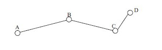 |
| Fig.1. Traverse Survey |
In traversing, the surveyor moves from one point to another by simultaneously measuring bearings and distances by "dead reckoning". Dead reckoning is the process of calculating the current position of some moving object by using a previously determined position. Employed when the construction work is long and narrow ( tunnel or motorway construction).
Scope and Objective of Traverse Survey
A Traverse survey is conducted to establish horizontal control in land areas, especially in areas where the line of sight (LOS) is short due to heavily built-up areas, where the survey methods triangulation and trilateration are not applicable.The main objective of the traverse survey are:
- To locate or establish boundaries
- To achieve horizontal control for topographic surveys
- To locate and prepare construction layouts for highways, railways, and other private and public works
- To conduct ground control surveys for photogrammetric surveys
Types of Traverse
The two types of traverse encountered while conducting surveys are:
- Open Traverse
- Closed Traverse
1. Open Traverse
 |
| Fig.2. Types of Traverse - Open and Closed Traverse |
The consistency of angles and distance measured cannot be checked in an open traverse. So, in order to minimize the errors, the distances can be measured twice, angles turned by repetition, etc.
2. Closed Traverse
 |
| Fig.3. Types of Closed Traverse |
How are Traverse Lines Measured?
The traverse lines are either determined by:
- Direct measurement: Tapes, EDM
- Indirect measurement: Tachometric Methods
- Angular measurement: Theodolite
Different Methods of Traversing in Surveying
Traverse surveying is a control survey that involves a number of survey lines forming a framework. The survey lines and directions are measured using distance-measuring devices and angle-measuring devices.
Usually, it is recommended to perform traversing using a theodolite and a tape to measure the angles and distances respectively. However, any combination of linear and angular measuring devices can be used.
The different methods of traversing are mentioned below:
- Chain Traversing
- Free or Loose Needle Method of Traversing
- Fast Needle Method
1. Chain Traversing
2. Chain and Compass Surveying - Free or Loose Needle Method
3. Theodolite Surveying
3.1. Included Angle Method
- Included angle method of traversing makes use of theodolite to determine the included angles.
- Hence, the method is suitable only for closed traversing.
- After setting the instrument at A, fore-bearing to line AB is determined (Fab) and AD (Fad) is also determined. Hence, the included angle, x = Fab-Fad.
- Now, set the instrument at B, and find the North direction. At B, determine the fore-bearing of line BC (Fbc) and back-bearing of line BA (Fba). Then the included angle, y = Fba-Fbc.
- Now, set the instrument at C, and find the North direction. At C, find the fore-bearing of line CB
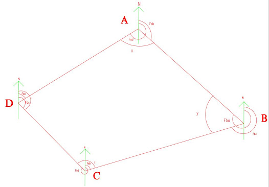 |
| Traverse Using Included Angle Method |
(Fcb), and the fore-bearing of CD (Fcd). Hence, the included angle, y = 360 - ( Fcd-Fcb).
- Now, set the instrument at D, take the fore-bearing of line DA (Fda), and the back bearing of line DC (Fdc). Hence, the included angle, l = Fdc-Fda.
- The linear measurement AB,BC,CD, and DA are measured either using a tape or a chain.
3.2. Fast Needle Method
3.3. Deflection Angle Traversing
- Mostly employed for open traversing
- Used for location survey of railways, pipelines, highways, etc..
 |
| Traverse by Deflection Angle Method |
- Place instrument at A and find magnetic bearing of that line AB.
- Now set instrument at B, sight A and set the instrument reading to zero. Transit the telescope, (now the instrument is set along the direction of line AB). Now measure the deflection angle by sighting to C.
- Now place the instrument at C, sight B and set the instrument to zero reading. Now transit the telescope and sight D. This gives the deflection angle at C.
What is the Procedure to Perform Traverse Survey?
- Reconnaissance
- Selection of Traverse Stations
- Linear and Angular Measurements
Step 1: Reconnaissance
- The surveyor goes to the field and checks the entire area.
- He decides the best plan of working.
- He checks the intervisibility of the traverse stations
- He decides the method of traversing to be adopted
- Based on the method chosen, the instruments and accessories are selected accordingly.
Step 2: Selection of Traverse Stations
- A minimum number of traverse stations should be selected.
- Take the length of the traverse line as long as possible to reduce the time and centering effect of stations.
- Try to select stations on a level and firm ground
- After selecting the stations, mark them using pegs.
3 Comments
I really appreciate this page, quite an in-depth analysis.
ReplyDeleteThanks and Regards
ReplyDeleteThank you
ReplyDeleteCommenting Spam Links Are Against Policies